
|
April - June 2001 |
 |
 |
| 1)
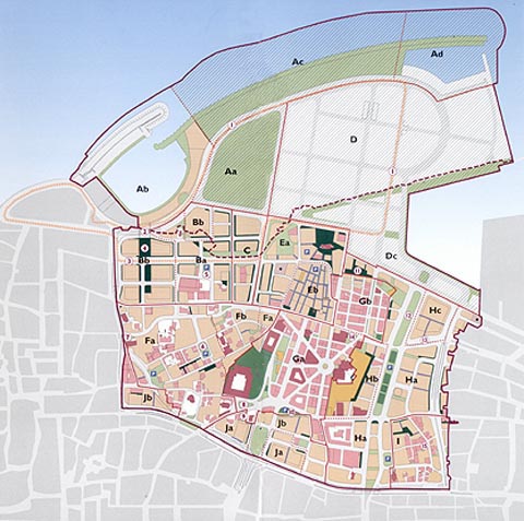
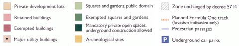
Preliminary planning of the Formula One racing track,
as per Council of Ministers' resolution 40 of November 23, 2000. 2) Adding a pedestrian bridge near the Beirut western marina to provide a link from the hotel district to the marina. 3) Widening Zeitouneh street to improve traffic conditions. 4) Widening the private unbuilt area between highrise buildings in the hotel district to create breathing space. 5) Adding an underground car park under the public open space near the Hilton hotel. 6) Adding a public open space with a public underground car park in the Wadi Abou Jamil residential neighborhood. 7) Creating a public open space near St Elie church. 8) Creating a public open space near the Grand Serail entrance (demolition of the existing building). 9) Creating a public open space near the Evangelical church. 10) Delineating Riad El Solh Square according to the actual landscape design, and the planned underground car park. 11) Building a private underground car park to service the Foch-Allenby area. 12) Specifying the site for the study of two bridges above the Ancient Tell, as per Council of Ministers' resolution 40 of November 23, 2000. 13) Amending the Cadmos street alignment to preserve archeological remains. 14) Building an underground car park facing the Municipality building to service the Foch-Allenby area. 15) Creating a public open space in the Saifi area. |
| With
the publication of Council of Ministers' decree 5714 of June
19, 2001, the city center is back on track. The decree was issued
following resolution 13 of May 24, 2001 which approved the updating
and amendment of the BCD Master Plan and regulations, together with
1/500 maps and the exact delimitation of the reconstituted public
domain.
This was the last step in a long procedure started by SOLIDERE in 1999 to resolve outstanding Master Plan issues. The decree will allow the final delivery by SOLIDERE of the completed infrastructure and reconstituted public domain, executed by the Company on behalf of the State as per law 117/1991, the Company articles and the 1994 agreement with the State. It is also crucial for the accounting of development areas in the BCD. Finally, by resolving any apparent contradictions between the original Master Plan and the national building code, it will allow the release of easement and alignment certificates; facilitate property lot subdivision and regrouping schemes as needed for development projects; and enable developers to register property transfers and obtain construction permits in order to start implementing their projects. Around 28 building permit applications will thus be unblocked, affecting both SOLIDERE and other developers in the city center. Traditional BCD Area Distribution Public domain
Development areas
|