|
||||||||||||||||||||||||||||||||||||||||||||||||||||||||||||||||||||||||||||||||||||||||||||||||||||||||||||||||||||||||||||||||||||||||||||||||||||||||||||||||||||||||||||||||||||||||||||||||||||||||||||||||||||||||||||||||||||||||||||||||||||||||||||||||||||||||||||||||||||||||||||||||||||||||||||||
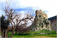
Tour Programme & Schedule 1-Musailaha fort Observation Notice that
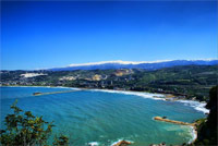
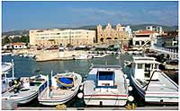
--------------------------------------------------------------------------------------------------------------------------------- Batroun The coastal city of Batroun (Greek: Βοτρύς, Arabic: البترون) located in northern Lebanon is one of the oldest cities of the world. Batroun is home to a Lebanese Red Cross First Aid Center. The name Batroun derives from the Greek, Botrys (also spelled Bothrys), which was later Latinized to Botrus. Historians believe that the Greek name of the town originates from the Phoenician word, bater, which means to cut and it referes to the maritime wall that the Phoenicians built in the sea to protect them from tidal waves.[2] Other historians believe that the name of the town is derivative of the Phoenician words, beit truna, which translates to house of the chief. Batroun is a major tourist destination in North Lebanon. The town boasts tens of historic churches, both Catholic and Greek Orthodox. The town is also a major beach resort with a vibrant nightlife. Citrus groves surround Batroun, and the town has been famous, from the early twentieth century, for its fresh lemonade, which is sold by most of the cafés and restaurants on its main street. In 551, Batroun was destroyed by an earthquake, which also caused
mudslides and made the Cape Lithoprosopon crack. Historians believe
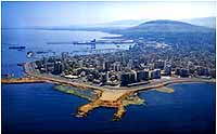
that Batroun's large natural harbor was formed during the earthquake Tripoli (Standard Arabic: طرابلس Ṭarābulus; Lebanese Arabic: طرابلس Ṭrāblos or Ṭrēblos, Greek: Τρίπολις Tripolis, Turkish: Trablusşam) is a city in Lebanon. Situated north of Batroun and the cape of Lithoprosopon, Tripoli is the capital of the North Governorate and the Tripoli District (In Lebanon the districts are subunits of governorates). The city is located 85 km north of the capital Beirut, and can be described as the easternmost port of Lebanon. In ancient times, it was the center of a Phoenician confederation which included Tyre, Sidon and Arados, hence the name Tripoli, meaning "triple city" in Greek. Later, it was controlled successively by the Assyrian Empire, Persian Empire, Roman Empire, the Caliphate, the Seljuk Empire, Crusader States, the Mamluks, and the Ottoman Empire. The Crusaders established the County of Tripoli there in the twelfth century. Tripoli is today the second-largest city and second-largest port in Lebanon, with approximately 500,000 inhabitants, overwhelmingly Sunni Muslims (approximately 80%), along with small communities of Christians and Alawite Muslims. The city borders El Mina, the port of the Tripoli District, which it is geographically conjoined with to form the greater Tripoli conurbation. Just offshore is a string of four (4) small islands, only islands of Lebanon. The largest, known as the island of Palm trees or Rabbit’s (جزيرة الارانب) island, is now a nature reserve for green turtles and rare birds. Declared a protected area by UNESCO in 1992, camping, fire building or other depredation is forbidden. This island also holds Roman and Crusader remains.
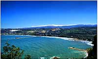
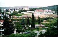
Koura or El Koura (Arabic: الكورة) is a district (in Arabic qadaa) in the North Governorate, Lebanon. Koura is one of the 36 districts of Lebanon, which is very popular for the olive tree cultivation. It is known by its dark green color. A total of 52 villages make up the Koura area. Koura's capital is the town of Amioun, (24000 official inhabitant, statistics of 2006, but less than 5000 permanent residents). It is geographically diversified, so present 3 types of land, a costal side to the Mediterranean sea, a large olive plain and include some villages in the mountains. Kfarhata, one of Koura's villages, is stated by many international figures to be "Heaven on Earth". It is mainly an Orthodox Christian district. The olive plains of El Koura are estimated to be the largest olive plains in the world. Kouranian people were living for centuries from this kind of agriculture. It has been known that the olive crop in the area is of extremely fine quality. The importance of Kouranian olive trees is that they offer an excellent quality of olive oil, extracted through the cold manner. It is also known in Lebanon, that El-Koura is the “human-cistern” of extremely educated people, mostly because during the 20th century, major changes impacted local population at this district (which was based on agriculture of olive, olive oil and olive soap production, and with lesser extent on cultivation of grapes and silkworm cocoon), and modified it into a now highy educated society in Lebanon.
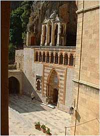
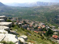
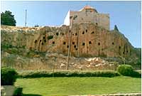
Amioun Amioun in Arabic: أميون and other scripts of the name, are most probably transliterated from the original Amyūn. It is the capital town of the predominantly Greek Orthodox area Koura District (i.e. χωριά, villages in Greek) in the North of Lebanon. The name is not strictly Semitic (Ammun = “the tough & firm fortress”), the Aramaic alternative ("`Am `Yuwn", the "Greek People") is also not the basic original, even though it was used in certain dialects for some time. According to the historian Condor, this “Amia”, none other than present-day Amioun, may be considered one of the oldest towns in the interior of Lebanon. With the advent of Christianity, the places of worship of local gods in Amioun were transformed into churches whose bells signalled the triumph of the faith - whereas Father Lamens in his book “The Monuments of Lebanon”, mentioned a number of towns, “Amia” is one (p.76). Saint George Cathedral: erected over a former temple at the highest populated spot of the town, as mentioned in a circular written by instructor of history in the official Lebanese schools Choukrallah Al-Nabbout. (Fig. 1) Saint John "al-sheer" church: Elevated on a rocky cliff over a number of vaults in the southeastern facade of the cliff. A Triple scene of a Crusaders church (1099-1100) panoramic over the 28 man-made crypts in the facade whose carbon-dating suggests 15000-24000 years of age. (Fig. 2 & 3) The town of Amioun, is known being a site for the Battle of Amioun, a historical clash in 694 A.D. between the Byzantine troops, under the leadership of Murik and Murikian, and some followers of the Monothelite doctrine, as mentioned in the article below by Chedid Al-Azar.
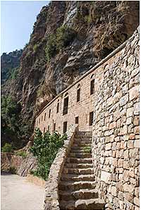
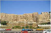
Al-Mousailaha Fort The Mseilha Fort (Arabic: قلعة المسيلحة) also known as "Puy du Connétable" is a medieval stronghold situated north of the city of Batroun in Lebanon. The fort overlooks the Nahr El Jawz valley from atop a steep sided rocky spur] The Crusaders built the first fortifications during the Middle Ages and then it was rebuilt by Emir Fakhreddine II in the 17th century to guard the route from Tripoli to Beirut. The Mseilha fort was given to the Genoese Embriaco family who ruled over Gibelet by Bertrand de Saint-Gilles for employing the Genoese fleet in his service during the taking of Tripoli
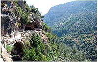
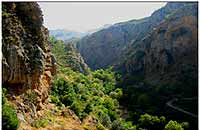
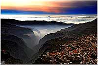
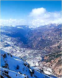
The Kadisha Valley (also known as Qadisha Valley, Wadi Qadisha, Ouadi Qadisha, or وادي قاديشا in Arabic) lies within the Becharre and Zgharta Districts of the North Governorate of Lebanon. The valley is a deep gorge carved by the Kadisha River, also known as the Nahr Abu Ali when it reaches Tripoli. Kadisha means "Holy" in Aramaic, and the valley, sometimes called the Holy Valley, has sheltered Christian monastic communities for many centuries. The long, deep Qadisha Valley is located at the foot of Mount al-Makmal in northern Lebanon. Through it the Holy River, Nahr Qadisha, runs for 35km from its source in a cave (grotto) a little way below the Forest of the Cedars of God. The sides of the valley are steep cliffs that contain many caves, often at more than 1000m and all difficult of access. The most scenic section of the valley stretches for approximately twenty kilometers between Bsharri (بشري), the hometown of Kahlil Gibran, and Tourza (طورزا). It is here also that the Holy River, Nahr Qadisha, flows, its source being in a sacred mountain celebrated in the Scriptures. The Qadisha Valley’s many natural caves have been used as shelters and for burials back as far as the Palaeolithic period. The Aassi Hauqqa (cave) in particular, near Hawqa, Lebanon, has yielded archaeological items indicating Palaeolithic, Roman, and medieval periods of use. Since the early centuries of Christianity the Holy Valley has served as a refuge for those in search of solitude. Historians believe that the Kadisha Valley has had monastic communities continuously since the earliest years of Christianity. Early Christian sects fleeing persecution found refuge in the Kadisha. Among these groups were the Jacobites (Syrian Orthodox), Melchites (Greek Orthodox), Nestorians, Armenians, and even Ethiopians. The Maronites, however, are the dominant Christian sect in the valley. From the late 7th century, Syrian Maronites fled to the valley from their original areas of settlement in the Orontes Valley. At that time, they feared persecution from the Byzantines, who accused the Maronites of supporting monothelitism. Maronite settlement intensified in the 10th century following the destruction of the Monastery of St Maron. The Maronite monks established their new center at Qannubin, in the heart of the Qadisha, and monasteries quickly spread over the surrounding hills.[2] Early Maronite settlement in the valley combined both community and eremitic life. The Mameluk sultans Baibars and Qalaoun led campaigns in 1268 and 1283, respectively, against the fortress-caves, monasteries, and the surrounding villages. Despite these attacks, the Deir Qannubin monastery was to become the seat of the Maronite Patriarch in the 15th century and to remain so for 500 years. In the 17th century, the Maronite monks’ reputation for piety was such that many European poets, historians, geographers, politicians, and clergy visited and even settled in the Qadisha. The first printing press in the middle east was built in 1610 at the Monastery of Qozhaya in the Kadisha valley. It used Syriac characters. Also this printing press was the first to print in Arabic language[4] [edit] The Qadisha mummies Main article: Maronite mummies Eight well preserved natural mummies of Maronite villagers dating back to around 1283 A.D. were uncovered by a team of speleologists in the Qadisha Valley in 1991. These were found is the 'Asi-al Hadath cave along with a wealth of artifacts.[5] [edit] World Heritage Site In 1998, UNESCO added the valley to the list of World Heritage Sites because of its importance as the site of some of the earliest Christian monastic settlements in the world, and its continued example of early Christian faith.
Christian Monasticism in the Valley The Kadisha (Holy) Valley is the site of some of the most ancient Christian monastic communities of the Middle East. The valley’s natural caves, being comfortless, scattered, and difficult to access, provided monks and hermits sufficiently isolated and inhospitable conditions to live out Christian solitude, contemplation, and devotion. Many of the caves and irregularities in the cliff-sides were adapted to serve as individual dwellings (cells), chapels, and monasteries, and such buildings were further carved out of the cliff faces of the valley. Some have interiors covered with frescoes and facades. Around the caves there are terraced fields made by the hermits for growing grain, grapes, and olives. While there are numerous monasteries in the valley, there are several main monastic complexes: The Qannubin Monastery The Qannubin Monastery (Deir Qannubin (دير قنوبين)), is on the northeast side of the Qadisha Valley. It is the oldest of the Maronite monasteries; although its foundation is often attributed to the Emperor Theodosius the Great in 375AD, it is more likely that it was established by a disciple of St Theodosius the Cenobite. For the most part it is cut into the rock cliff side - monastic cells, church, cloister, and accommodation for travelers. Qannubin used to be the See of the Maronite Patriarch. The Monastery of St Anthony of Qozhaya Monastery of Qozhaya - July 2003 The Monastery of Qozhaya (Deir Mar Antonios Qozhaya (دير مارانطﻮنيوﺱ ﻗﺰحيا)) sits on the opposite flank of the Qadisha from Qannubin Monastery. Tradition has its foundation in the 4th century by St Hilarion, in honour of the Egyptian anchorite, St Anthony the Great, though the earliest documentary records date back only to around 1000AD. It was destroyed in the 16th century but quickly restored. It comprises a corridor, meeting room, and chapel, with a mill and a number of hermitages cut into the rock nearby. [edit] The Monastery of Our Lady of Hawqa
Saydet Hawqa is situated at an altitude of 1150m between Qannubin
and Qozhaya Monasteries, at the base of an enormous cave. It was
founded in the late 13th century by villagers from Hawqa. The
hermitage appears to have been located on a wide platform at
mid-level, where there is a water reservoir fed by channels. The
upper level, only accessible by ladder, is a cave some 47m long,
where the wealth of medieval pottery and arrowheads that have been
found suggests its use as a refuge. Traces of fortifications have
also been found in the Aassi Hauqqa (cave) at 1170m altitude.
Archaeological finds show that this cave was in use in Palaeolithic,
Roman, and medieval times. The Monastery of Mar Sarkis
Monastery of Saints Sarkis & Bakhos, Ehden The Monastery of Mar Sarkis, also called Ras Al Nahr, overlooks Ehden, Kfarsghab, Bane and Hadath El Jebbeh. Given its exceptional location overlooking the valley at an altitude of 1500m, the monastery is called the Watchful Eye of Qadisha. It is dedicated to Saints Sarkis and Bakhos (Saints Sergius and Bacchus). The name Ras Al Nahr means the top of the river as it is in the vicinity of the Mar Sarkis source, the main contributor to the Qlaynsieh River which joins the Qannubin River in the valley. The first church of Saints Sarkis and Bakhos was built in the mid 8th Century A.D. on the ruins of a Canaanite temple dedicated to a god of agriculture. Next to it, another church dedicated to Our Lady was constructed in 1198 A.D. Several buildings were added from 1404 till 1690, when Patriarch Estephan Douaihy restored part of the buildings. The Monastery of Mar Lishaa The monastery of Mar Elisha is perched on the cliff.
Mar Lishaa or St Elisha (دير مار ﺃليشع), mentioned first in the 14th
century, is shared by two communities, a Maronite solitary order and
the Barefoot Carmelite order. It consists of three or four
small cells, a refectory, and some offices; the communal church
includes four chapels cut into the rock-face.
Other monasteries Other monastic establishments in the Qadisha are the Monastery of Mar Girgis, with the Chapel of Mar Challita, the Monastery of Mar Yuhanna, the Monastery of Mar Abun, with the Hermitage of Mar Sarkis, and the Monastery of Mart Moura, Ehden. There is another group of monasteries in the adjoining Hadchit Valley (Ouadi Houlat). These were founded by Ethiopian Monophysite monks expelled from the neighbouring town of Ehden and occupied by them before their communities scattered elsewhere. They include the hermitage-monastery complexes of Deir es-Salib, Mar Antonios, Mar Semaane, and Mar Assia, along with the isolated chapels of Mar Bohna and Mar Chmouna.
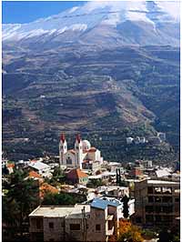
Cedars The Cedars of God The Kadisha Valley is nearby the Forest of the Cedars of God,
survivors of the ancient Cedars of Lebanon, the most highly prized
building materials of the ancient world. The forest is said to
contain 375 individual trees, two claimed to be over 3000 years old,
ten over 1000 years, and the remainder at least centuries-old. The
Lebanon Cedar (Cedrus Libani) is described in ancient works on
botany as the oldest tree in the world. It was admired by the
Israelites, who brought it to their land to build the First and the
Second temples in Jerusalem. Historical sources report that the
famous cedar forests were beginning to disappear at the time of
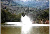
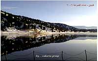
Justinian in the 6th century AD. Benash'ei is a village located in the Zgharta District in the North Governorate of Lebanon. This village is known for its water and agriculture (Apples, Pears, Grape, Peaches, and Cherries). 90% of its population migrate during the winter months to coastal cities like Zgharta, Mejdlaya, Tripoli, Chekka, Batroun, Jbeil, Jounieh and Beirut. Al Bouhairi has 10 families, permanently settled in the village and more than 100 residences, most of those being used mainly during summertime. Also, large numbers of its citizens migrated since the end of the 19th century to Australia, Venezuela, United States, England, France, different African countries. The lake now is a very important destination to all who search
about the quiet , calm and the wonderful nature.
أصل التسمية :
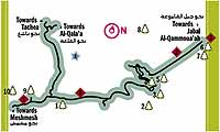
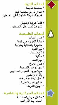
المواقع السياحية والأثرية:
|
|
|||||||||||||||||||||||||||||||||||||||||||||||||||||||||||||||||||||||||||||||||||||||||||||||||||||||||||||||||||||||||||||||||||||||||||||||||||||||||||||||||||||||||||||||||||||||||||||||||||||||||||||||||||||||||||||||||||||||||||||||||||||||||||||||||||||||||||||||||||||||||||||||||||||||||||||
|
-Daily Tours starts at
9.00am or in demand -For lunch or dinner add 30.00$ for each meal -Choose and arrange your trip on your demand also -All tours depart from your hotel or residence place, and dop-of also there -Also, ask about cities (Aley, Bhamdoon, Broumana, Beitmery, Afqa waterfalls, Ibrahim river, Litani river, Assi river, Musailaha fort, Zahle city,etc) -We can arrange religious tours all around lebanon -All the tours have a guide with excluding rate -The packages do not share any other tourists -To order any of these above mentioned tours, email us : barakat.travel@lebanon.com |
||||||||||||||||||||||||||||||||||||||||||||||||||||||||||||||||||||||||||||||||||||||||||||||||||||||||||||||||||||||||||||||||||||||||||||||||||||||||||||||||||||||||||||||||||||||||||||||||||||||||||||||||||||||||||||||||||||||||||||||||||||||||||||||||||||||||||||||||||||||||||||||||||||||||||||||